Climbing Mt Taranaki
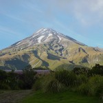
Midway through a New Zealand road trip, I’ve set aside one day to climb Mt Taranaki, a 2518 metre volcanic peak. The mountain is also known as Mt Egmont, and is in Egmont National Park, south of New Plymouth in the North Island.
Unfortunately for me, the weather forecast for the day I’d set aside (Sunday 3 Jan) wasn’t too good: drizzle, with a northwest gale (at 2000m elevation), rising to 80 km/h in the afternoon. However, I was fairly well equipped (with a rain jacket, overpants, fleece jacket, merino wool long johns, wool/possum fur gloves (a great NZ innovation), fleece beanie and good waterproof boots), so I decided to give it a go anyway.
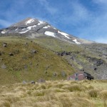
I set off from the North Egmont Visitor Centre (elevation 936 metres) at around 7:20 am, along with my father, who hiked with me for the first 40 minutes or so. The first third of the climb (in terms of the total elevation gain) is a hike along a 4WD track up to the private Tahurangi Lodge, at elevation 1492 metres. The first part of this track is nicely sheltered by the forest, but the second part is more exposed, and the strong winds here gave a foretaste of what was to come later.
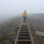
After the lodge are the wooden steps: just as easy to walk as the 4WD track, but with a greater rate of climb. They cross a rocky gully, which still had a patch of snow in it; I stopped here for a break, which also gave a group of hikers below me a chance to catch up. The steps then head up towards a ridge where the real challenge begins: scree. To tackle this, I was happy to have the company of the hikers who had caught up: it was a kiwi family (mum, dad, son, daughter and (Canadian) son-in-law).
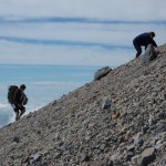
Before I decided to do this climb, I’d read a couple of descriptions of the hike from other hikers (sorry, “trampers”). They’d described climbing the scree as “for every step foward, you take two back” and “a heart breaking section”, so I knew it was going to be bad, but I really didn’t expect it to be as bad as it was. Some spots are firmer than others, and the ridge does seem to be better, but that’s also where it was windiest. The real trick (as used by one of the mountain guides we encountered, along with his group) is to head west (anti-clockwise) around the mountain, to where there is a section of solid rock. We didn’t learn about this until we’d finished the scree, and I don’t know why the marked trail doesn’t take that route. Towards the end of the scree section, I did head over that way; it was easier, although the rock was all over the place, so I had to use hands as well to clamber up.
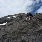
This type of climbing continued for the next section; it’s hard to say, but I’d guess it was around a 45 degree slope. There was no one path marked, but everyone chose their own route, while not straying too far from the route marking poles. The clouds remained below us, but it seemed like they were following us up the mountain as we went. The wind however kept getting stronger the higher we climbed.
The rock section ends when you reach the crater rim, which is eroded away in a few places, including the northeast direction of our approach. With the serious climbing done, I zipped my trouser legs back on here, and also put on a rain jacket, mainly to protect against the wind. I also switched my cap for a beanie, to avoid the cap being blown off.
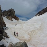
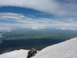
Getting to the summit requires crossing the snow that remains in the crater; hiking guides recommend that you have crampons for this section, but we managed with little difficulty to get up the slope, as the snow was soft enough that you could create good footings, rather than slipping down the slope. At this point, we were regularly being enveloped in cloud — one minute it would be clear (like the photo above) and the next you’d be in the cloud, with visibility quite reduced. So we hurried up to the summit (getting there about 1pm), and enjoyed the views (when the clouds gave us the chance). Thanks to the communications tower near the lodge, it was also possible to send a text message! Then, the cloud closed in for good, and we started back down. This is where things started getting a bit hairy.
First, the cloud deposited a fine mist on my glasses, so they were just like frosted glass, so I couldn’t see where I was going. It was fine at first, as I just headed down the snow slope, but when I got to the flatter part, I needed to see where the guys in front were, and the combination of cloud and droplets on my glasses made that impossible. I’m quite short-sighted, so I need my glasses all the time; this time however, it was going to be better to have a very blurry image without my glasses rather than the diffuse forms visible through them. So, I did the rest of the descent without glasses.
The next challenge was to find somewhere sheltered to stop for lunch, since the wind had continued to increase. This took us a fair way back down the rock section. A couple of ham-and-cheese sandwiches later, we continued the descent, which I found incredibly difficult.
As I mentioned, I was somewhat blind, so I wasn’t too sure exactly where I was putting my feet. Then, the wind had reached gale force (as the forecast had predicted); in fact, one of the group thought it might be 100 or 120 km/h. It was gusty as well, so the variability and strength of the wind made it very tricky to stand up and keep your balance. The wind brought with it the moisture from the cloud, along with dirt and grit from the slope — so we slowly became soaked, with grit in the eyes and everywhere else. The terrain was the final challenge, first the rocky section, and then the scree. Thankfully, it was possible to descend the scree in short, somewhat-controlled slides, but these often ended when your feet slid out from under you. Descending should be less physically demanding than ascending, but I was so exhausted by this point that it seemed just as hard going down. And we’d pretty much lost sight of the trail markers as well, and were guided by recollection of the landscape from the ascent. (Rather, I was guided by those who could see the landscape clearly, and remembered it as well.)
We finally reached the steps, which slowly took us out of the main brunt of the wind. The footing was much improved, and so the rest of the hike down was just putting one foot in front of the other (being as gentle on your knees as possible), and putting up with the remaining wind and cloud, and later, rain. We got back to the car park around 4:45 pm, or thereabouts: a bit over 9 hours on the trail.
I’m glad I did the climb (and survived), but I’ve learned some new respect for the power of nature. If I’d been less well equipped, or hadn’t had the encouragement of the group I’d met up with, I could have been in real trouble. Over 60 people have died on Mt Taranaki, usually caught unprepared when the weather turns, and I can now understand why.
Well done Mate!
I just climbed Taranaki for the first time yesterday, in much better conditions than you had, and it was still bloody hard coming down.
You’ll be back for more!